Drainage & Slope Analysis From Aerial LiDAR Data Mapping and Modeling

Updated: 4 days ago
Water goes where the ground tells it to. Aerial LiDAR data scan turns a site into a precise, measured model of the bare earth, so engineers, surveyors, and designers can see how water will actually move across it—before it becomes a grading conflict, a ponding issue, or a puddle on a pad.
From point cloud to a surface
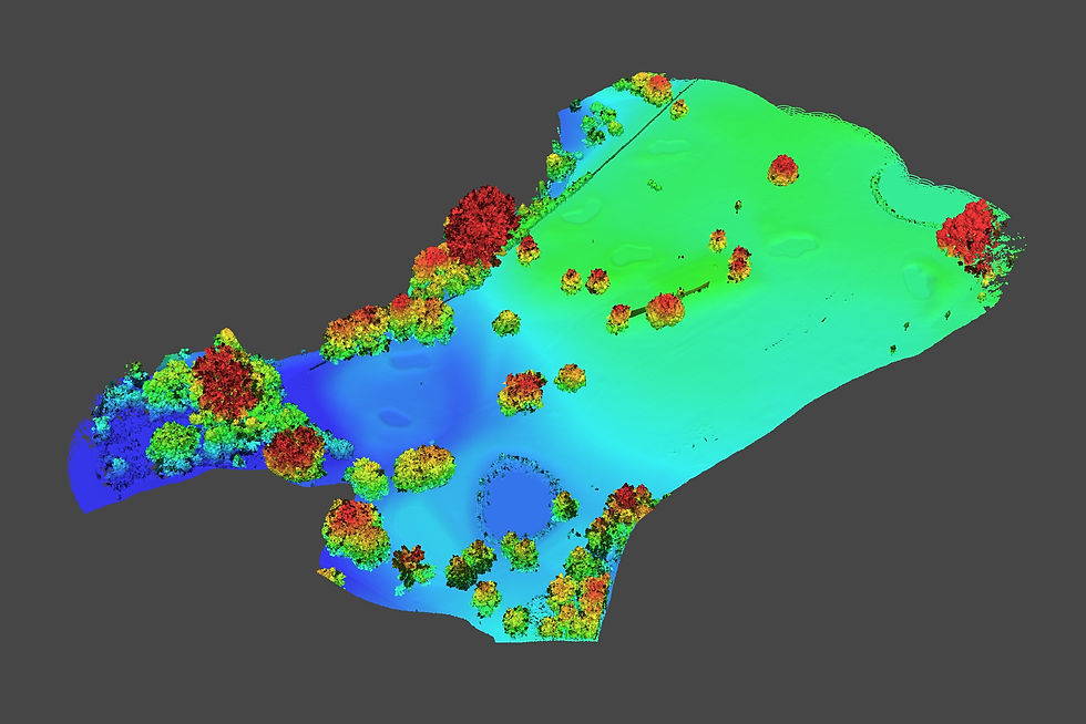
LiDAR produces a dense point cloud: millions of individual points, each with a precise location and elevation, collected across the site. Those points are classified to separate ground from vegetation, structures, vehicles, and other above-ground objects, then processed into a terrain model representing the actual earth beneath them.
From that bare-earth surface, drainage analysis can be derived to support civil and site design: slopes, flow paths, catchment areas, swales, ridges, breaks in grade, and low spots. It is the difference between designing against measured elevations and designing against assumptions.
What it answers
A properly processed LiDAR terrain model can help identify:
Where water naturally sheds and where it will collect.
Which existing grades will move water—and which will not.
Where ponding is likely to form after rainfall.
How runoff moves toward buildings, pavements, inlets, ditches, wetlands, or adjacent properties.
What a regrade, drainage feature, or drainage correction needs to change.
Whether the existing site condition matches older mapping information or design intent.
These are not simply visual observations from imagery. They are data products built from measured elevation points: a ground model that can be delivered in formats civil, engineering, and GIS software can use directly.
Why objective data beats assumptions
Drainage problems often appear where plans and present-day conditions no longer agree.
Over time, sites change. Fill is placed, pavement is replaced, curbs are modified, landscaping grows, utilities are repaired, structures settle, and small grading changes accumulate. Even a subtle elevation difference can redirect water toward a building, across a driveway, or into a persistent low area.
Older mapping data may still be useful context, but it may not describe the ground as it exists today. A current LiDAR-derived bare-earth model can reveal the low spot missing from an old plan—often the same location where water is already collecting.
Measuring the site before design begins is typically less costly than discovering the actual drainage pattern after construction, after a major rain event, or after a recurring water complaint.
The canopy advantage
Drainage answers are only as good as the ground model beneath them. On sites with trees, brush, tall grass, or other vegetative cover, that is where LiDAR matters most.
Aerial photography and photogrammetry capture the visible surface. In an open parking lot, field, construction site, or closely mowed lawn, that visible surface may be close to the actual ground. Under tree canopy or dense vegetation, however, RGB imagery generally records the canopy or vegetation surface—not the terrain below it.
LiDAR sends laser pulses toward the ground and can record multiple returns from a single pulse. Some returns come from leaves and branches, while others may pass through gaps in vegetation and reach the ground. After classification and careful quality control, those ground returns can be used to build a bare-earth terrain model beneath cover.
That makes LiDAR particularly valuable for drainage corridors, wooded lots, stream banks, ditches, stormwater features, rural properties, utility routes, and sites where the important grades are hidden below vegetation.

Common questions
LiDAR or photogrammetry for drainage?
If the site is open and unobstructed, photogrammetry can produce a useful elevation surface. If the site has tree canopy, brush, tall vegetation, or terrain hidden from the camera, LiDAR is generally the better tool because it can capture ground returns beneath that cover.
The key question is not which sensor is more impressive. It is whether the resulting model represents the actual ground surface that controls water movement.
What deliverable do I get?
Deliverables can include a classified LiDAR point cloud, a bare-earth digital terrain model (DTM), contour data, slope maps, Hillshades, flow-direction and flow-accumulation products, drainage catchment areas, and GIS/CAD-ready elevation data.
The goal is to provide data your civil engineer, designer, or GIS workflow can use—not simply an aerial image or a visual site overview.
How accurate does it need to be?
It depends on the grade tolerance, design purpose, site conditions, vegetation, access, and required deliverable. The required accuracy drives the data-collection plan, LiDAR sensor configuration, control or checkpoint process, processing workflow, and quality-assurance method.
We collaborate with your engineers and surveyors to collect aerial LiDAR data to the specifications needed for effective planning, design, and decision-making.
For drainage and grading work, the right approach is to define the design tolerance first, then scope the LiDAR data collection and validation method honestly around that requirement.
Next step
If water is finding a low spot your plans do not show—or you do not understand how it is getting there—measure the ground as it exists now. LiDAR provides the point-cloud data needed to build a true bare-earth terrain model, especially where vegetation hides the grades that control drainage. Read more about LiDAR and Mapping.
Reach out to ScenePhoto360 with the drainage question or problem you are experiencing (or trying to avoid). We can help turn the site’s existing ground conditions into usable elevation data for the people designing the solution.
About the author

Earl Bakke is a Level II Certified Thermographer and FAA Part 107 pilot with night-operations authorization. Twenty years in law enforcement and crash reconstruction, 450+ ground, LiDAR, building, and thermal inspections, and testimony in criminal and civil proceedings. He founded ScenePhoto360 in Stillwater, Minnesota. Read the full background.